FIRST ALERT WEATHER DAY: Tornado Watch active in some Mid-South counties

MEMPHIS, Tenn. (WMC) - The National Weather Service has issued a Tornado Watch in the following Mid-South counties until midnight:
- Alcorn, MS
- Benton, MS
- Lafayette, MS
- Marshall, MS
- Panola, MS
- Quitman, MS
- Tippah, MS
- Hardeman, TN
- McNairy, TN
A severe weather outbreak is expected across the Mid-South Friday evening.
TIMING: The main timing will be between 5 PM and Midnight as storms moves west to east.
Ahead of the storms, temperatures will soar into the upper 70s to lower 80s. This warm air will help increase instability, which could result in severe thunderstorms, especially across North Mississippi.
The Storm Prediction Center (SPC) has issued a MODERATE RISK (Level 4/5) for severe weather. It’s not very often the SPC issues a Level 4 or greater.
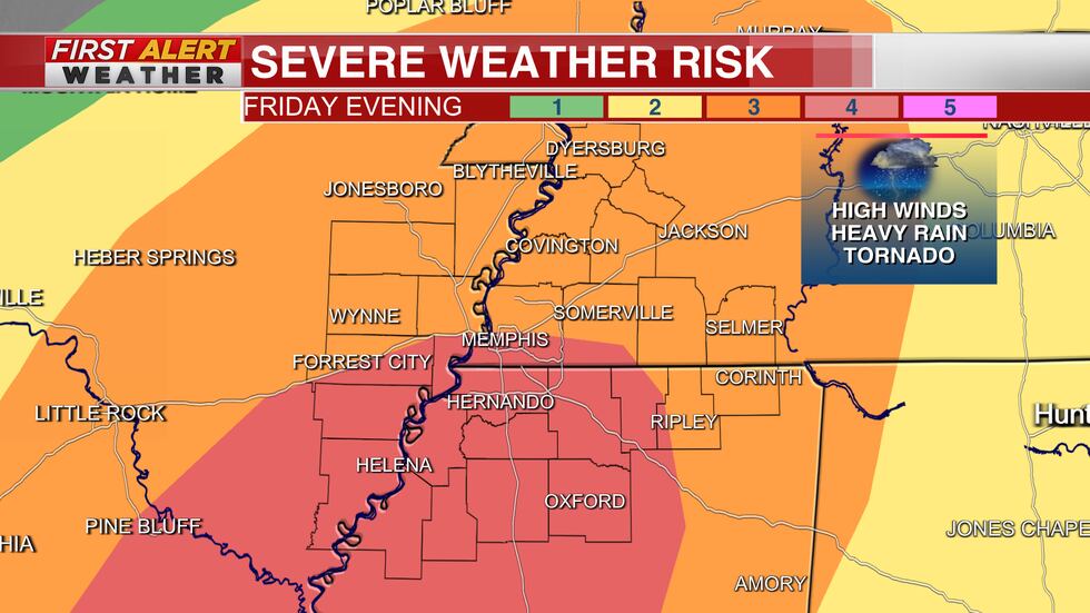
THREATS: Main threats include damaging winds and heavy rainfall that could lead to Flash and Areal flooding.
Secondary threats include tornadoes, of which a few could be strong.

Flooding caused by excessive rainfall will be possible.
A FLOOD WATCH remains in effect for areas north and west of Memphis through Saturday morning.
Rainfall amounts of 2 to 3 inches are possible in the Watch area, with isolated higher amounts.

A WIND ADVISORY remains in effect until 3 AM Saturday.
South winds 20 to 30 mph with gusts up to over 45 mph expected.
Gusty winds could blow around unsecured objects.
Tree limbs could be blown down and a few power outages may result.

STAY ALERT: Prepare now for severe weather and stay weather aware today and tonight.
Stay tuned to the First Alert Weather Team.
Be sure to download the WMC First Alert weather app for Apple or Android to your smartphone or tablet. It’s FREE and will give you instant access to current weather conditions and forecasts for your specific location.
You’ll also have a live, interactive radar and should any advisories or warnings be issued for your location you will get them instantly on your phone or tablet.
UPDATE: The Mid-South has been downgraded. The Storm Prediction Center has downgraded the Moderate Risk to an Enhanced Risk. The current line is making its way across the Mid-South right now.
UPDATE: The Tornado Watch has been cancelled for Hardeman County, TN, Panola County, MS, Benton County, MS, Quitman County, MS.
Click here to sign up for our newsletter!
Click here to report a spelling or grammar error. Please include the headline.
Copyright 2023 WMC. All rights reserved.